


Hiking Project
คำอธิบายของHiking Project
โครงการไต่เขาเป็นคู่มือที่ครอบคลุมของคุณเพื่อการเดินป่าที่ดีที่สุดใกล้บ้านคุณไม่ว่าคุณจะอยู่ที่ไหน
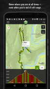
ด้วยความละเอียดถี่ถ้วนของแผนที่ที่พิมพ์ออกมาเราขอเสนอข้อมูลเส้นทาง GPS แบบเต็มโปรไฟล์ระดับความสูงคุณสมบัติการโต้ตอบรูปภาพและอื่น ๆ เช่นเดียวกับหนังสือนำเที่ยวเราขอแนะนำการเดินป่าที่โดดเด่นที่สุดในการสำรวจไม่ว่าจะใกล้กับตำแหน่งปัจจุบันของคุณหรือในพื้นที่ที่คุณค้นหา ผู้เชี่ยวชาญในท้องถิ่นแสดงไฮไลท์คุณสมบัติที่ท้าทายและข้อมูลเชิงลึกที่คุณต้องการในการวางแผนวันอันยอดเยี่ยมบนเส้นทาง
•ค้นหาเส้นทางกว่า 74,000 ไมล์เพื่อไต่เขากับทีมของคุณ
•เส้นทางใหม่จะถูกเพิ่มอย่างต่อเนื่องในฐานข้อมูลการเดินป่าที่มีรายละเอียดของเราอย่างไม่น่าเชื่อ
•ตำแหน่งที่แน่นอนของคุณจะปรากฏบนเส้นทาง
•เส้นทางที่ดาวน์โหลดทำงานแบบออฟไลน์เมื่อคุณไม่อยู่ในกริด (ไม่จำเป็นต้องรับเซลล์!)
•เพลิดเพลินกับภาพถ่ายความละเอียดสูงและแผนที่เส้นทางภูมิประเทศโดยละเอียด
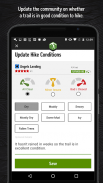
•เราจะซิงค์กับรายการที่ต้องทำของคุณและเช็คอินที่ HikingProject.com
โดยใช้ GPS เราสามารถแสดงตำแหน่งของคุณบนเส้นทางและโปรไฟล์ในแนวตั้ง การใช้งาน GPS อย่างต่อเนื่องในพื้นหลังสามารถลดอายุการใช้งานแบตเตอรี่ได้อย่างมาก
ลิงค์:
•นโยบายความเป็นส่วนตัว: https://www.adventureprojects.net/ap-privacy
•ข้อกำหนดในการให้บริการ: https://www.adventureprojects.net/ap-terms
Hiking Project - ข้อมูล APK
เวอร์ชั่น APK: 25.18.0แพ็คเกจ: com.hikingproject.androidเวอร์ชั่นล่าสุดของHiking Project
เวอร์ชั่นอื่น


 3.67
3.67


แอปในประเภทเดียวกัน


